
-
 66593 Hits
-
 88.61% Score
-
 27 Votes
|
|
Area/Range |
|---|---|
|
|
40.18478°N / 121.71038°W |
|
|
Hiking, Bouldering, Scrambling |
|
|
Spring, Summer, Fall, Winter |
|
|
Overview
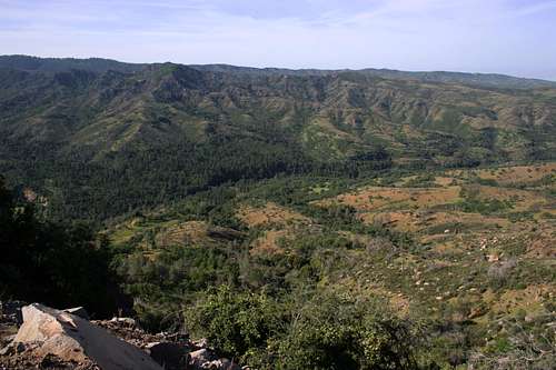
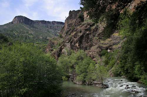
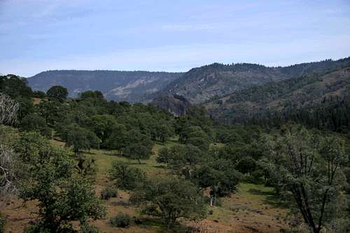
Mill Creek Canyon
California’s Ishi Wilderness is one of the most unusual and dramatic wilderness areas in the Golden State. A region of deep canyons lined with bizarre rock formations and roaring mountain rivers, the Ishi is found in a remote and largely forgotten corner of California’s Cascade region. The wilderness area encompasses 41,840 acres of the Lassen National Forest, most of which is found in low elevation ranging from 1,500 to 3,500 feet above sea level. This results in one of the Ishi’s superlative attributes; during winter, when the rest of California’s prime backcountry is covered in several feet of snow, a trip to the Ishi Wilderness affords the chance for an excellent wilderness backpacking trip complete with abundant wildlife and fishing in one of the most fantastic fishing streams in the state.
In addition to the scenic and wild values of the Ishi Wilderness, the area also affords some of the best opportunities for wildlife viewing in the state. All of the usual suspects are found here in abundance. The area is also home of the Tehama deer herd, the largest migratory herd in the state. On one trip here in January 2007, elusive animals such as foxes, eagles and cougar were all spotted. In addition to the abundant wildlife, the Ishi is also one of the most historic wilderness areas in the state. The aboriginal existence of the Native Americans came to an end in this area.
Regional Map

Geography
The Sierra Nevada rise north of the Tehachapi Pass in southern California and travel several hundred miles to finally taper off gradually into a broad flat area called Mountain Meadows. This basin now contains Lake Almanor. The Cascade Mountains begin in Canada around Mt. Garibaldi and form the main mountain crest through Washington and Oregon. They extend into California and finally peter out in the Mountain Meadows, just south of Lassen Peak. The western foothills for both ranges blend together in this region, forming a unique area exhibiting the influences of volcanism, water and wind. Stretching from Oroville to Red Bluff, these foothills are cut by numerous dramatic canyons. Butte Creek Canyon and Chico’s fantastic Bidwell Park, which contains Big Chico Creek, are typical examples of the canyons formed of ancient lava flows eroded by large mountain streams.
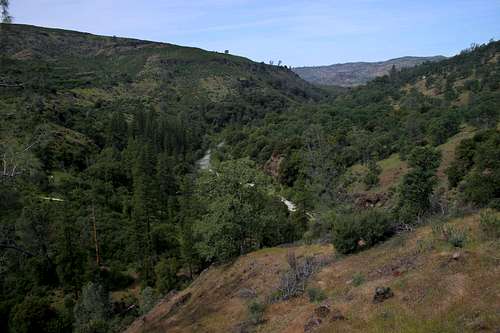
Mill Creek
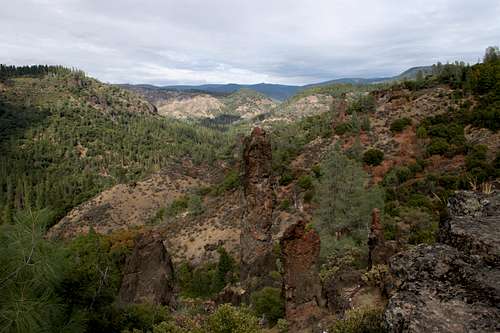
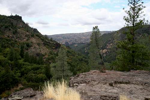
Deer Creek Canyon
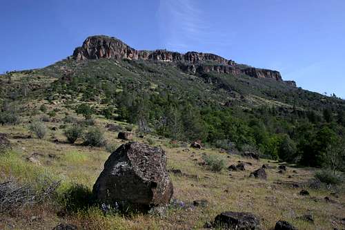
The Ishi Wilderness occupies the northern expanse of this Cascade-Sierra foothill region. The 41,840 acre wilderness is anchored by Deer Creek Canyon in the south and Mill Creek Canyon in the north. Boat Gunwale Creek and Big and Little Dry Creeks drain the interior of the wilderness, each with its own canyon. The strata visible in the canyon walls is evidence of the different lava flows that covered the mountains. The volcanic past of the Ishi Wilderness is also seen in the numerous basalt formations that line the canyon ramparts. Most of the formations are pinnacles of hardened lava. While Mill Creek Canyon has several interesting formations, the best are found in Deer Creek Canyon. However, Mill Creek Canyon is the home of the Black Rock, one of the most striking features of the Ishi. The Black Rock is a weathered volcanic plug, the remains of a small, ancient volcano. The monolith towers about 250 feet above Mill Creek. Unable to erode the Black Rock, Mill Creek winds around its base. Although just outside of the official wilderness boundary, the Black Rock is visible from several areas within the wilderness and is the dominant landmark at the Mill Creek trailhead.
The headwaters of Mill Creek are on the southern slopes of Lassen Peak. After passing through Child’s Meadow, it flows into Upper Mill Creek Canyon, which is located above the Ishi Wilderness, northeast of the Black Rock. A trail runs the length of the canyon in that area as well. Currently a Forest Service Wilderness Study Area, the upper canyon may be added to the Ishi Wilderness at a later date. Averaging around 1,500 feet deep, Lower Mill Creek Canyon is one of the most spectacular parts of the wilderness. The canyon walls are lined with dramatic basalt cliffs and pinnacles while the lower area flattens out into rolling terrain. Mill Creek’s classification as a “creek” is misleading. It seems more a river than a creek, with a large volume of water and numerous rapids. Even in winter it still has a substantial flow. During spring its power is sobering. Most of the rolling terrain in Mill Creek Canyon is covered with classic oak savannah. Occasional digger pines and small, isolated stands of ponderosa pines are also present. Springtime wildflowers are abundant. Mill Creek also contains numerous active springs. These are found at the base of the basalt cliffs on the north side of the canyon and form cool, clear streams. One of the springs forms an small waterfall high above Mill Creek and can be seen as well as heard from the bottom of the Canyon.
Although it is not as deep as Mill Creek Canyon, Deer Creek Canyon is narrower. The basalt pinnacles are more abundant and easier to access in this canyon as well. Their presence is testified by names like “Devil’s Parade Ground”, “Devil’s Kitchen”, and “Devil’s Den”. Deer Creek Canyon also boasts a phenomenon known as pineries. These are isolated plateaus with large stands of ponderosa pine. The Beaver Creek pinery is found on the north side of Deer Creek Canyon, while the Graham pinery is found on the south side. The headwaters of Deer Creek are found in the final southern stretch of the Cascades, just north of the Mountain Meadows area. While it is not as large as Mill Creek, it is still a voluminous body of water with a precipitous drop as it flows towards the Sacramento River.
Ishi Wilderness Map

History
Mill Creek Canyon
In prehistoric times, the Ishi Wilderness and the surrounding region was the home of the Yahi Yani Indians. They traveled in small bands and hunted and fished the area. When gold was discovered in 1848, prospectors poured into the foothills of the Sierra Nevada. The Cascade-Sierra foothills witnessed a similar phenomenon. Prospectors originally blazed the Lassen trail, which still exists as an unmaintained pathway in the heart of the Ishi. The Yahi Yani managed to remain unmolested by the encroaching Americans by retreating into remote regions of the canyons. Once the gold deposits played out, the presence of those searching for gold dissipated and the area was again left to the Yahi Yani.
However, the surrounding regions became settled and the Yahi Yani were eventually reduced to a small band, still hiding in the canyons. One by one they died out, until in 1911 a lone Yahi Yani named Ishi was left. He was found hiding in barn in Oroville, south of the present day boundary of the wilderness area. A University of California anthropology professor, who later wrote a book titled “Ishi”, took him in. The book detailed much of the Yahi Yani way of life, as recounted by Ishi himself. Ishi adapted to early 20th century life fairly easily and was content to remain in the Bay Area, never desiring to return to his homeland. His departure from the traditional home of the Yahi Yani marked the end of the aboriginal existence of Native Americans.
Other than a couple of claims with some developed, albeit rustic, homesteads, the canyons once occupied by the Yahi Yani retain their wild character. The most notable claim is found at the head of Lower Mill Creek Canyon. A small house with some outbuildings is found in the first quarter mile of the trail. A few cows and a couple of horses are allowed to roam free in this area. Nonetheless, the canyon remains a wild place in spite of this outpost of civilization.
Trails and Trailheads
Seven trailheads serve the Ishi Wilderness. All but two of them provide access to Mill Creek Canyon or Deer Creek Canyon.
Mill Creek
Deer Creek Canyon
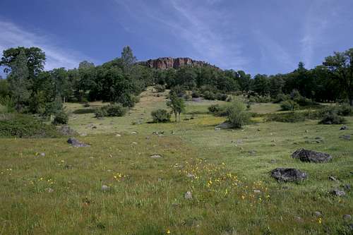
Table Mountain Trailhead:
Table Mountain looms over the western end of Mill Creek Canyon. The trail to it begins at the Table Mountain Trailhead and descends a ridgeline to the top of the mountain. A trail to Kingsley Cove also originates at the Table Rock Trailhead.
Rancheria Trailhead:
Like the Table Mountain trailhead, the Rancheria is located on the north rim of Mill Creek Canyon. The Rancheria Trail descends to the bottom of Mill Creek Canyon along the banks of Rancheria Creek. The trail is nice going down, but back up is a whole lot of no fun.
Mill Creek Trailhead:
The trail winding through Lower Mill Creek Canyon originates here. It travels 6.5 miles before terminating at Papes Place, an old homestead. This is the best trail in the wilderness and makes an ideal winter or springtime backpacking trip. Water is abundant and is available from both Mill Creek itself and the numerous spring fed streams along the north side of the canyon. The trail through Upper Mill Creek Canyon also originates at this trailhead.
Lassen Trailhead:
Located on the eastern border, in the center of the wilderness, this trailhead is one of the access pointes for the Lassen Trail. This pathway is faint, waterless and hot. This is not one of the better trails in the area and is rarely used.
Moak Trailhead:
Like the Lassen Trailhead, the Moak is located on the eastern border, in the center of the wilderness. However, the trail is an excellent springtime option. Although waterless, it travels through open, oak savannah country, with excellent wildflower displays and views of the Sacramento Valley.
Deer Creek Trailhead:
Like its northern counterpart, the Mill Creek Trail, the Deer Creek Trail follows its namesake stream on its north shore. It is closer to the strange basalt columns than its northern twin, but is generally further away from the creek. Deer Creek is a classic mountain stream and fishing is good. Due to its relatively easy access from Chico, this is the most popular trail in the Ishi Wilderness. This does not mean crowds, just a somewhat higher likelihood of seeing other hikers. A trail following the Upper Deer Creek Canyon terminates here. It begins north of Chico off Highway 32.
Devil’s Den Trailhead:
The Devil’s Den Trail begins on the opposite side of Deer Creek from the Deer Creek Trail. It winds up the Little Pine Creek drainage. The most interesting feature of this trail is the access it provides to the Graham pinery.
Getting There
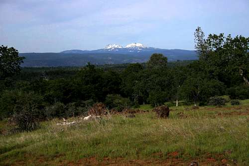
Lassen Peak and Brokeoff Mountain from Plum Creek Road, on the way to the Ishi Wilderness
From Red Bluff, head east on Highway 36. At Paynes Creek, turn right onto Plum Creek Road. Stay on Plum Creek Road for several miles. The road will wind in and out of a few drainages and eventually head east along a ridge. Lassen Peak and Brokeoff Mountain are visible to the northeast. Turn right (south) onto Ponderosa Way. Signs indicate a distance of 20 miles to the Black Rock Campground. The road quickly becomes a dirt road. After five miles, the quality of the road degrades significantly as the route drops into two major drainages; North and South Forks of Antelope Creek. The road drops down several hundred feet on one side of the canyon and then climbs back out. Eventually a ridge is crossed and Mill Creek Canyon comes into view in the distance. The road falls 1,500 feet over the next three miles, finally joining Mill Creek adjacent to the Black Rock. Ponderosa Way continues south, skirting the eastern boundary of the Ishi Wilderness, eventually dropping into Deer Creek Canyon. It provides access to the Lassen and Moak trailheads along the way. At the Black Rock, turn right just before the bridge and enter the Black Rock Campground. The trailhead to Mill Creek Canyon is at the west end of the campground.
From downtown Chico head north to the town of Cohasset on Cohasset Road. At the town of Cohasset, the road is renamed Ponderosa Way and becomes a good quality dirt road. The route eventually drops into Deer Creek Canyon and crosses a bridge, where the trailhead for the Deer Creek Canyon is located. Ponderosa Way continues north from here, skirting the eastern boundary of the Ishi Wilderness and leading to the Black Rock Campground.
Red Tape
Basalt Cliffs line the rim of Mill Creek Canyon
Normal wilderness rules and ethics apply. Permits are required for any overnight travel in the wilderness. No permits are required for day hiking. Only one permit is necessary for a group but it is only good for one trip. The area does have some archeological sites. It is illegal to tamper or remove anything with archeological value.
Some parts of the Ishi Wilderness have been placed within the Tehama Game Refuge and it is illegal to hunt in these areas, particularly the area south of Mill Creek Canyon.
Lassen National Forest
2550 Riverside Drive
Susanville, CA 96130
(530) 257-2151
The Ishi Wilderness is located in the Almanor Ranger District.
(530) 258-2141
Camping
The Black Rock from the interior of the Ishi Wilderness
Four primitive Forest Service campgrounds are located along the outskirts of the Ishi Wilderness. The Black Grove and Long Point Campgrounds are located on the north rim of Mill Creek Canyon, near the Table Mountain and Rancheria Trailheads, respectively. The Black Rock Campground is located on the banks of Mill Creek at the Mill Creek Canyon trailhead. In the south, the Gaither Camp Campground is on the banks of Deer Creek, a short distance from the Deer Creek Canyon and Devil’s Den trailheads.
Dispersed camping is permitted in most areas outside of the campgrounds, as well as in the wilderness. Be sure to obtain a campfire permit from any Forest Service office.
External Links
U.S. Forest Service Ishi Wilderness Site
Lassen National Forest